It was a great flight up to Paso Robles. A little over two hours in the air. All the things that I love about flying. Dramatic paths cut through the clouds, an entirely different view of the way the weather lies on the land, a view all around the broad circular band of the horizon.
Following my virtual lines in the sky, drawn by the clever technology of radio transmitters and recievers, I scooted up the coast, past Santa Barbara and over the mountain range between the coast and the first part of the desert basin. Paso Robles sits on this plain, between the wet of the coast and the dry of the desert.
Whenever I fly cross-country (from airport to airport) I have the air traffic controllers watch me on thier radar screen. I mean, they can always see me, and my little transponder pings out my altitude and the special code (1200) that tells them that I am just navigating on my own (visual flight rules, VFR, flying), but they don't know who I am or where I am going. If I dropped suddenly into the sea (or close enough to the sea to go off their radar screen) they don't know if that's a planned event or not. They can't really do much. So I call. I say, "Hello Los Angeles Center, this is Cherokee triple-seven victor pappa with a request." That tells them I am a little airplane (Piper Cherokee), and they know I am VFR (because they have no listing in their system yet for N777VP).
Only once have they been too busy to help. Usually they deal with some other things (like Southwest flight 6387 and United Heavy 820) and then come back to me, "Seven seven seven victor pappa, what is your request." "I'm headed to Paso Robles, just over Pacific Palisades at two thousand five hundred feet and I would like flight following." There's often a pause while they dial some stuff into the computer that tracks all the flights. "Seven seven seven victor pappa, squawk three four three two." So I dial that into the transponder and the next time the radar sweep hits my little tin plane, bing, I show up on their screen with my tail number (N777VP), destination, and altitude. Then they will talk to me along the way.
On the way up to Paso Robles yesterday the controller called and said, "Seven seven seven victor pappa, turn left to heading three four zero for traffic." So I comply and repeat the instruction back, flying along for four minutes at the new heading, and then he calls me again and says I can resume my own navigation. The little deviation means I stayed very clear of some other airplane he had on his screen. Chances are that I would have seen the other plane, or he would have seen me, or if we had passed close to one another it would have been within a few hundred feet, but this way he gives me information about things I can't see, which is a nice thing.
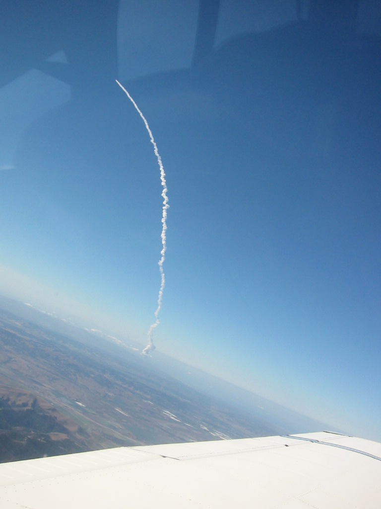
As I was passing by Santa Barbara the controller at Santa Barbara Approach said, "All planes if you look west in ten seconds you will see a missile launch." I did a little count down in my plane and a second later there was a bright around flash under the clouds near the coast. Vandenburg Air Force Base was right over there. Then the missile shot up. Boy, it was something to see. I remembered a little late that I had brought the camera along, so I snapped a photo.
The automated weather service recording at Paso Robles had a broken sensor (they fixed it as I was leaving), so the visibility reported was a quarter mile. As a pilot on the ground said as I went by, "A bird must have shit on the lens." I was too far out (twenty-five nautical miles) to see the airport, but I decided that it must be wrong and that I would at least fly over the airport to see. It was ten miles visibility at least. It was my fiftieth flight.