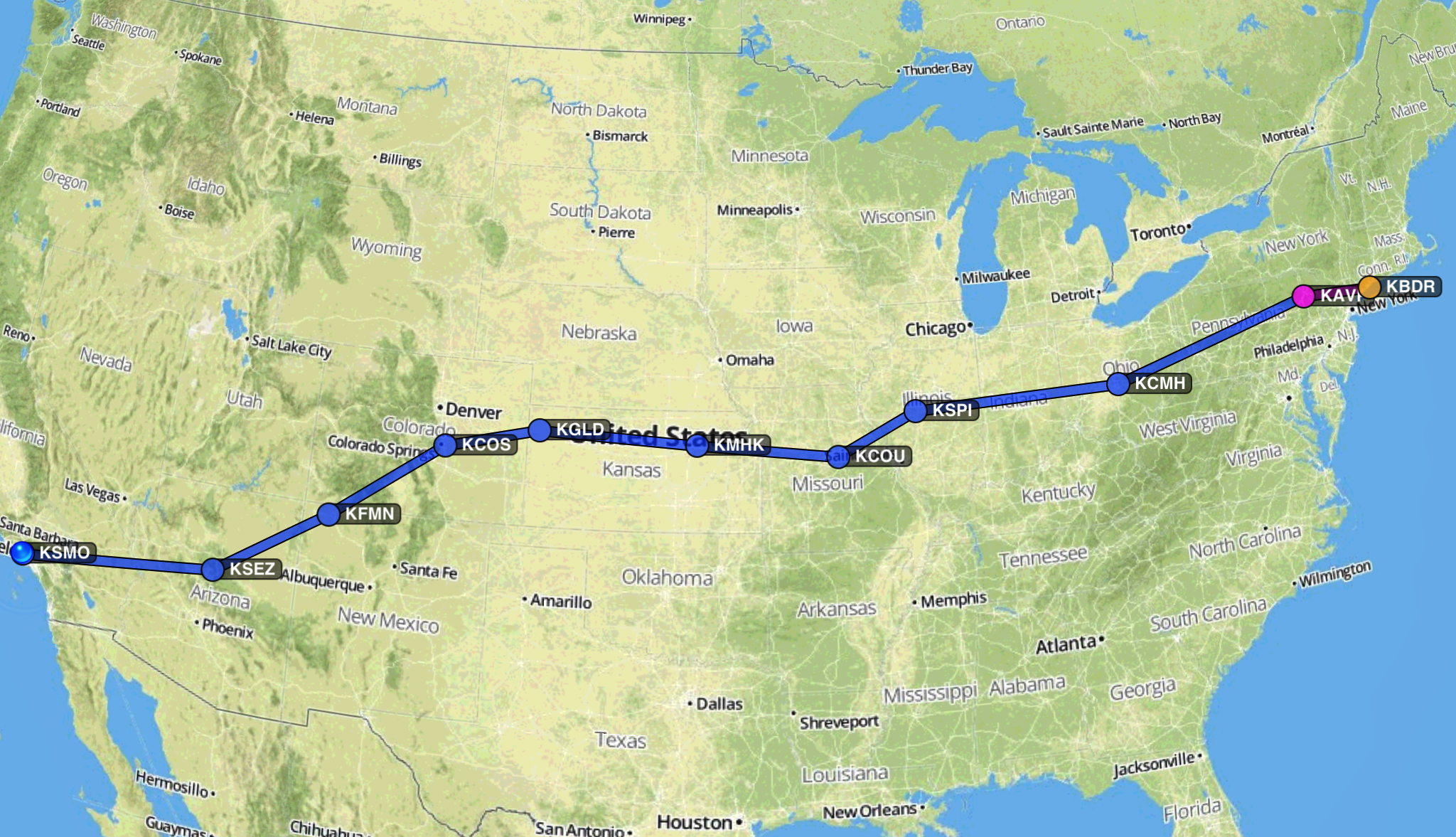
BDR – AVP
Bob Whitehead, my business partner, decided that he’d rather brave the little plane than the cattle car of SouthWest to get back to Santa Monica.
Nell convinced me that the smart thing to do was to fly up to Bob’s place in Pennsylvania the night before (the plane was at Bridgeport, CT getting an oil change). So I took a Metro North commuter train out of Grand Central Station and up to Bridgeport. The train ride was longer than the plane ride across the Alleghenies.
There was an overcast sky, so I had filed an IFR flight plan, but it was a high ceiling over both airports and the few airports in between. I checked the chart and although there was rising terrain west of the Hudson it wasn’t high enough to meet the clouds. I would squeeze through VFR, which is more fun since I would get to sightsee along the way. The best laid plans…
Departure out of Bridgeport was flawless and they handed me off from controller to controller for flight following. The New York controllers are famously busy, especially on a day where a bunch of the flights are IFR due to the weather, so I think they were happy to have my just bee-lining on my own. Unfortunately, just as I crossed the Hudson the clouds started moving down a little and the Alleghenies rose up to meet them. I couldn’t be positive, but it sure looked like they were meeting a little further west.
In California, particularly southern California, this is a non-issue. I call up the controller and ask for a clearance into my destination airport. I remain clear of the clouds until I get it, but then they read it over the radio and I am set to go. The New York Controllers really don’t have time for this stuff. They have dozens of commercial flights that they are juggling and routing. So the guy I spoke to was a little bent out of shape. “You’re VFR now, but you want to be IFR?” Yes. Clouds were not as forecast. “But you don’t have a clearance?” Well, I had one at Bridgeport, but I didn’t pick it up, because the clouds there weren’t as bad as they were forecast. “Well, that clearance is no good because you aren’t in Bridgeport anymore.” Right. “Okay, you’ll have to just circle and remain VFR while I try to get something into the computer.” Well, I wanted to take a look at the Hudson valley there anyway, so that was fine.
He came back after a couple turns and read me the clearance. They took me way down into New Jersey (or practically there, and up to nine thousand feet before letting me descend to the Scranton airport. There have been a bunch of accidents where planes on instrument approaches into Scranton crashed into the mountains, so I was vigilant, well-briefed and didn’t let me attention wander at all while I was in the clouds. Just before I started the approach I noted that I was between layers of clouds, in a thousand foot high space that no one above or below knew about. It was eerie and quiet, and difficult to make out exactly what the limits of the space were. I loved it. Then I followed the radio signal down to the ground, through the clouds at to the long runway at Scranton’s airport.
Bob picked me up and we had dinner at some Texas ribs place on the way back up to the old farmhouse we used to share when we were building houses. In the morning we drove back down and started our trek across the country.
Day One
August 23, 2007 (Thursday)
AVP - CMH
Although I made it across the entire country West to East in VFR conditions, our departure from Scranton was through the clouds. We were above the layer in less than five minutes, and we cruised on toward Pittsburgh. There were some thunderstorms on the NextRAD in a north-south line, so we headed south along their Eastern edge and ducked around them a little south of Pittsburgh. (So we were cleared into the Class Bravo around KPIT.) We might have even ventured into West Virginia, but at the time we were paying very close attention to how the large storms were moving rather than the state borders on the chart.
We landed in Columbus, Ohio for lunch. We borrowed a car from the FBO (Million Air, my favorite name for an FBO) and drove to Burger King. Oh, the glamour of private airplane travel. I actually had a grilled chicken sandwich that was entirely passable and we discussed how the real food content of the onion rings was probably lower than plywood.
CMH – CMI
We were flying about two or two and a half hours on a leg. Or at least that was our plan. A morning flight, lunch, an afternoon flight to a place to stretch our legs, a flight to dinner, then possibly a flight to where we would sleep. Everything depended on weather because there were huge thunderstorm lines marching east across the country. As we would duck and turn around them, altering our course, we’d look in “the little brown book” to see what size airport our fuel range was going to get us to (with a forty-five minute reserve in case we needed to go elsewhere). After landing in Columbus, that next stop was Champaign, IL, the airport of the University of Illinois-Willard, which seems to have some sort of aviation program. The airport is huge, but we were treated well even though we weren’t a big jet. It was nearly enough flying for the day, but we saw that if we just hopped a little more we’d make it to Springfield, IL, which probably had a more comfortable hotel bed.
CMI – SPI
Springfield is all about Abraham Lincoln. The limo driver (supplied by the hotel) offered to drive us past Abe’s house. We had traveled enough that day, so we declined the detour. The hotel was comfortable, and we were able to walk to an Outback Steakhouse for dinner. A steak is the perfect meal for this sort of trip because you just want some protein without a lot of bulk; all we were doing was sitting for hours on end using our brains. We walked back to the hotel through the high pitched whine of truck tires on the Interstate. They would roll while we slept.
Day Two
August 24, 2007 (Friday)
SPI – COU
The free breakfast in the hotel was delicious (lots of cut fruit, an omelet stand, fresh biscuits) and then we were headed to the airport for an early morning departure. The controller at Springfield seemed awfully surprised that we were headed west. Although my weather computer images didn’t show it on the ground before breakfast, there was a hundred mile wide storm headed toward Springfield. We ducked south all the way to St. Louis (Belleville, really), and then headed west. There was a lot of peering out the canopy at the darkening clouds, confirming with the XM weather picture and listening to the pilots ahead.
We were cleared into the St. Louis class Bravo, but I had already landed there on my way east, so it wasn’t on my list. The controller said that he thought there was a break we could sneak through if we headed to KVER, the Boonville, Missouri airport. I am more cautious than the controller (since I am in the plane), and I landed at Columbia, MO. The rain started as we were walking from the plane to the tiny FBO. They fueled us up, we planned the next leg, and we watched the thunderstorm sweep across the runway. It would not have been fun to be aloft in it.
COU – 3JC – MHK
The next leg was to Manhattan, Kansas. We were above the rain clouds for most of the way, and then descended through canyons and craggy holes in the clouds to the green plains below. The Manhattan tower didn’t answer radio calls (worth a blog entry all on its own), so we landed at a nearby un-towered field to refuel. Then we returned to Manhattan and landed without permission. The FBO was nice and let us borrow a car. We drove around a little but couldn’t find anything better than a McDonalds. Later, as we returned to the airport, we saw the place we should have been looking, but it was too late. It was my first visit to a McDonalds in over a year. While we were eating the storm we were edging alongside blew through the town and drenched the parking lots. There was a lot of wind and I was glad that the plane was well secured before we left the field.
MHK – GLD – COS
Kansas is flat. That’s what we have to tell you. It is so flat that the danger to the plane is really the transmitter towers that they have to build to near-plane-traffic height in order to communicate across the mind-boggling flatness. We landed in Goodland, after dodging a bunch of transmitter towers on the way in. The FBO there had good reviews and it was antiquated but very friendly and comfortable. It was nearing 5pm so, of course, they were shutting down for the day. It was an airport in the middle of nearly nowhere, near the center of the great expanse of flatness.
As we took off and flew toward the Rockies we knew that we didn’t want to cross at night. Examining the options and since we didn’t know we still had the oxygen unit working, we decided on a lower, southern route through the mountains. That called for a landing at Colorado Springs rather than Denver’s Centennial Field, where I had originally hoped to land. As we flew out of Goodland toward Colorado Springs the land started to climb in the first half hour. It was fun to be at our usual cruise altitude of 8,500 and see the ground slowly coming up to meet us. The airport at Colorado Springs is at 6,187 feet above sea level, three thousand higher than where we landed at Goodland.
As you fly over the plains, especially the near-featureless grassy plains of Kansas, it is impossible not to think of the original people that wandered this continent and what their days must have been like down there. From five thousand feet above the plain it was the same as far as our eyes could see, except for a few roads and a few changes in grass crop. In twenty minutes we would go fifty miles, probably further than a nomadic group could go in a day, and it looked exactly the same. The features were distant, and usually just a slight depression for drainage. They must have known where they were by the stars, and they must have simply followed the edge of a large herd, feeding and clothing themselves from the slowest members, but what did they think about their world, and did they know how far away the edges were?
We landed in the eastern foothills of the Rockies. Colorado Springs is a college town. In fact, many years ago one of my cross-country drives started here when I flew out to drive my cousin and his Audio Quattro back east. The cruise control was broken, which I remember being a drag, but we had some good tunes and good weather most of the way. He was finishing up a year at Colorado College at Colorado Springs. Actually, now that I think about it, I’m not sure it was Colorado Springs, maybe it was Boulder, Colorado. I can remember that we had a tape deck with auto-reverse, but I can’t remember the town we started in.
Our dinner was in a “terminal” adjacent to a huge Air Force plane that had been converted to a diner. It was a little loud but the food was better than McDonalds. I think. I was a little buzzed from the day of flying. It takes a lot of concentration to navigate around the storms and into strange little airports. I slept like a felled tree.
Day Three
August 25, 2007 (Saturday)
COS – FMN – SEZ – SMO
The hotel was not as comfortable as the sumptuous place in Springfield. I slept, but the instant I woke up I wanted to be out of the room. We hit the free breakfast. I had a western omelet that was cooked in some little mold like a brick. It was a yellow, chewy, slightly cheese-flavored brick of egg. English muffins are hard to make bad, though, so I mashed the omelet down with one of those, cantaloupe, honeydew, and a lot of water. We headed to the airport for our earliest departure of the trip. There was a sad looking fellow there waiting in the little FBO lounge while they fueled his Cessna. He had to wait for the field to go VFR and there was a five hundred foot overcast ceiling. I had filed at the hotel and we picked up the clearance in the plane.
Bob talked to the lineman the day before about the weather. The local said, “Well, everything goes into the big granite mixing bowl west of the city and gets churned up until it is ugly enough to pour out the sides.” This didn’t make Bob very happy about our prospects of crossing the Rockies. I have read many, many accident reports about mountain rotors, mountain waves, downdrafts of 4,000 feet per minute and various bogey men that inhabit the high altitude, mountainous terrain. I was on high alert. I checked out clearance twice, studied the surrounding terrain on the chart, checked my approaches back into the airport in case I had to return for some reason, and we started our takeoff roll.
Climbing out we entered the clouds and I focused on the twin LCD panels. It was very heartening to see the terrain slowly turn to yellow (one thousand to one hundred feet below us) from the red (above or up to one hundred feet below us), and finally to a tan or brown that marked its elevation above sea level. Even inside the cloud we could see that the vectors that ATC had us fly angled us away from the highest ground and along a valley and toward lower ground to the east. They were very interested in a “tops report,” the altitude where we finally broken through the clouds (7,600 feet, about 1,500 feet above the airport), since we were one of the first planes out that morning.
We turned south and followed the high ridge to the west of Colorado Springs. We told ATC about the position of the cloud layer against the mountains and how far south and east it extended (as far as we could see). We were hooked up to our magic oxygen machine and we continued to climb until we were at 14,500 feet. (Legally, if we stayed above 12,500 for more than thirty minutes we had to have supplemental oxygen.)
Just as we were tracking the thunderstorms the previous day, we were tracking terrain today. We watched on the moving map with the range pulled fairly wide as the Rocky Mountains fifty miles to the west. The night before I had carefully plotted a route through that first set of imposing vertical characters. The DA40 is a good plane, but it is only four cylinders, one hundred eighty horsepower and no turbo-charging. Above eight thousand feet it climbs a little less than four hundred feet a minute, so it took more than fifteen minutes to climb to altitude. When we were finally up there we turned west.
Again, I was studiously examining the ground for emergency landing spots (plentiful!), checking the engine gauges and trying hard to make sure we were crossing each ridge at about forty-five degrees. I kept my hand on the control stick so that any moment I could turn tail and duck one hundred eighty degrees out of the teeth of a mountain rotor.
Other than a slight bump or two as we closed in on a brush with Blanca Peak (14,345), but I could see how there was an odd wind swirling around it. We deviated a little to get to some smoother air and continued on. It was one of the easiest legs of our flight (and not the shortest), and we landed smoothly in Farmington, New Mexico.
It was such an easy leg, and we had gotten off really early morning, so we set a minimum amount of time on the ground of forty-five minutes. It was hard to kill the time, but critical for these middle-aged joints to have the time walking around the FBO and the ramp. We also were past the highest points in the Rockies, so it was all downhill from here. We saddled back up and headed for lunch.
Sedona, Arizona has decent food, but you fly in for the sights. It rivals Catalina’s Avalon Airport for the most dramatic arrival we have made in the plane. It is perched atop a mesa and is surrounded by red rock cliff faces and mountains. It’s just gorgeous. On my approach the fellow in front of me went around, so I also went around. He had slowed his approach and hung over the runway, so I just stayed at pattern altitude and over flew the airport. There are a lot of accidents around this airport because of the quickly rising terrain on three sides, high altitude, and the unpredictable winds funneled around by the cliffs. I have a lot of respect for the accident database and so I was extremely aware of where the plane needed to be.
I ate most of my cheeseburger, and we dawdled in the terminal checking the weather some more. There wasn’t much point, since this was Arizona back to Southern California. There were a few rain storms near Las Vegas, but that was a considerable distance from our route. It was hard to get back into the plane for another three hours, but we were topped off and there was no reason to delay.
One more taxi up to the departure end, one more engine run up. There was an Aerostar that took off before us. We heard them almost all the way back, trying to get into Big Bear and then heading to Las Vegas. There were serious rain clouds over both, and maybe there were problems getting in. We flew three hundred forty-two more nautical miles. I just kept waiting for the big turn at Daggett. At that point we would just be on the last half of our usual milk run back from Las Vegas. I’d still be flying, but I wouldn’t be scouring the ground for emergency landing spots, wondering if we’d lost the ATC frequency somehow, or wandered into restricted air space. I’d be back on my home turf and I could practically let the horse run to the barn.
There was a brief moment over Rialto where the SoCal approach controller thought that our destination was Santa Ana instead of Santa Monica, so they were vectoring us across the approach course for Ontario and were confused that we kept jerking at the bit to head west toward the ocean.
It was not my prettiest landing at my home airport, and the controller was way too busy to welcome us back, but it was very nice to climb out of the plane after three days of seven hours a day flying. Nell and the boys were there to meet us, having made the same journey in about a quarter the time.
I’d do it again in a minute. There’s nothing like seeing the country from a little plane just a few thousand feet off the ground.