Well, I made it all the way back across. The boys had a birthday party that they wanted to make it to, so Nell had to bring them home on JetBlue. She loved the flight east and was sad that she wouldn't get to fly west. I said in a couple years we would be able to send them on ahead while we brought the plane home for them.
They flew out early on Tuesday morning, so I did too. I was a little concerned about the autopilot, which was steering thirteen degrees to the right for the last few hours. I tried to get an avionics place to look at it before I took off, but they were too busy.
I helped them into a car which whisked them off to the JetBlue terminal at JFK. My friend Tod had come into the city from the same airport the night before, so I was able to return his rental car for him and save the cost of a hired car out to Caldwell, NJ. I had only planned my first stop. All I knew is that I was headed to Pittsburgh. It would take a little over two hours. I packed up the plane, got my "nest" all set in the front with my approach plates in a dozen books in the footwell of the passenger side, snacks within reach in the back. All the sun screens folded and organized into various pockets.
New Jersey was hazy and already getting a little warm. I was glad to be departing. The New York Center controllers were way too busy for a little plane like me, until I was called out as unidentified traffic and I politely identified myself. Then the controller happily gave me a squawk code. (That happened as I departed East Hampton Airport for Canada, too.) I dodged a lot of clouds out of New Jersey, the towering cumulous were already starting to build up at 10am, but I was able to remain VFR.
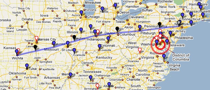
That's what eight and a half hours of flying looks like. Pittsburgh was a fun airport to land at, and the FBO could not have been nicer, but I didn't find a good meal there and was relegated to McDonalds. I wish I hadn't been in such a hurry to leave Manhattan and had taken the time to have a big, healthy breakfast at a diner. That would have made McDonalds unnecessary. Starting with the golden arches sort of put me off my feed for the rest of the trip.
My rule (from previous trips) was that I had to spend at least forty-five minutes on the ground. One way to use that time is one the flight planning for the next leg. Check the weather, check the route, research the FBOs at the next stop, and update the flight log and projected trip ahead. By the time all of that's done and the plane is fueled it's usually time to saddle back up. So it was off to KEYE in Indianapolis, IN next. It's supposedly an airpark's airport, but it seemed bigger than that. The FBO had great reviews and deserved them. The lineman that waved me into parking had a cooler and the moment I popped the canopy he handed me an ice cold bottle of water. I needed it.
Pittsburgh, PA to Indianapolis, IN might have been some of the best flying of the trip. There were clouds everywhere and I had to thread my way around them, curving back to my course whenever I could. Slipping between two towering clouds with a little more than my wingspan between them, I could really feel the speed of the plane.
Pushing on from Eagle Creek Airpark I was going to stop in Columbia, MO. Bob and I had stopped there on our flight west the previous summer. But all the review on Airnav said that the FBO was now terrible and that anyone that was any good had moved to the FBO at Jefferson City. That's why I do the research. I changed my destination to Jefferson City and headed back up into the sky.
I meant to take a photograph. There were two marks on the exterior wall of the FBO at Jefferson City, MO. One was for the 1993 flood (a little over my head as I stood on the tarmac in front of the building), and the other was the 1996 flood (another couple feet above 1993). Totally amazing.
In Missouri the controller cut me loose quite a bit before the airport. I just hummed along in the evening sky, listening to the iPod and keeping watch for other planes. It was extremely peaceful and it made me realize that by tethering myself to ATC for flight following I am giving up some of the calm and quiet that the pilots of other little planes might be experiencing.
I emailed Ying Ling, the FBO in Wichita, KS, and let them know I was coming. I said I would need a hotel room and the Hilton across the street from them sounded good. I checked the weather, checked my route and climbed back in for one more leg. I was gaining an hour here and there as I headed west, so the time was earlier, but it still felt late to me. I climbed into the plane in New Jersey at 9:30am for a 10:00am launch. It was 9:20pm when I climbed out onto the ramp at KICT, but it was really 10:20pm for me. That was over twelve hours of traveling, decision-making, weather-watching and communicating with a bunch of different people. The FBO had lost my hotel information, but five minutes on HotWire got me the cheapest room of the entire August trip: $63 at La Quinta. The FBO dropped me there and I headed straight to bed. I debated a stop in the hotel's steak house and bar, but I just couldn't face more people.
I looked at the weather radar websites in the morning and it was clear that if I had stopped in St. Louis (my original plan), I would have been stuck there at least until the early afternoon and probably later.
In the morning it was just a little harder to get out of bed than I had hoped it would be. I read the news a little and watched Dexter in the Weezer hootenanny. Island in the Sun got me moving. I wandered across the street to Denny's, where my half-awake brain was confused by the sign on the door. I wasn't sure if I was packing or not. And should I be? What if some nut job in there was packing?
Denny's has breakfasts that come to the table still sizzling in a pan. This is how I would like all of my scrambled eggs served. That's really great. I crisped my hash browns a little more. I thought about a national chain getting dinged for racism and whether it might have changed anything at the local level in any particular restaurant. It was good to stretch my legs walking back and forth to the hotel, and I could hear the hum of the Interstate above. That's the sound of long trips for me, especially when I am half awake. The hotel dropped me at the FBO where they had 1RD fueled and parked right in front of the door. Service!
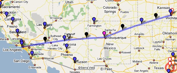
The heading indicator disappeared as I taxied around on the ramp, but I was pretty sure that was a localized problem. High concentrations of iron ore nearby, or something else that was interfering with the magnometer. I didn't sweat it and it went away as I rolled out onto the runway for takeoff. Wichita is where Cessna is based, so there were a lot of "Citation Test Six One Five..." sort of calls on the radio as I was departing. I turned nearly due west and headed to Guymon, OK.
There were overcast clouds above me for a while, and then they lowered to below me. I wanted to stop at a little field in Texas, but that morning they had an overcast layer and although I carried lot of approach books I didn't happen to have Texas with me. Next year I plan to correct that oversight. So I was on a bee line for Guymon, OK, where we had stopped on the way east. I dodged clouds on the way in, was happy to hear someone depart the field VFR, and I taxied up to the fuel pumps after a smooth landing.
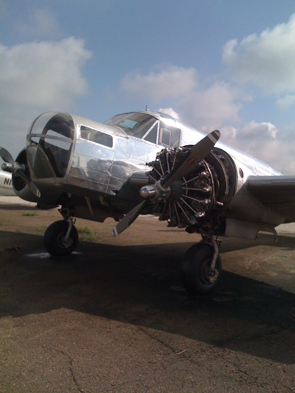
It might be the hardest forty-five minutes to kill, the one on the first landing of the day. Because you're fresh and feel like you could hop back in. I checked the weather and the route and took some photographs of a plane my brother was interested in. (It was a twin Beech E-18 with an observer's bubble on the nose. It had an accident on the field so it was sitting there forlorn with an engine hanging oddly off one wing.) The sky was filled with scattered clouds, so I climbed on the downwind, weaving in and out of clouds until I was high enough to turn west.
On the way to Albuquerque's Double Eagle airport I was at 10,500 feet and I saw a flock of birds going the other way. They were about half a mile off my left wing, dead level with me and seemed to be about fifty in number. Bird strikes can do significant damage, so I called ATC and made a report.
"Albuquerque Center, this is One Rome Delta, flock of fifty birds eastbound same altitude half a mile off our left wing.""One Romeo Delta, roger. Can you tell what sort of birds they were?"
"Looked to be ducks."
"What sort of ducks?"
"Um, we weren't that close."
Laughing, "Okay, thanks, we'll put it in."
It was especially worth noting that the birds were at ten thousand five hundred feet but were eastbound. That's not the right altitude for that direction of flight. Moments later another flock went by off my right wing and it made me wonder how high birds fly when they are migrating. It turns out that bar-headed geese have been seen up as high as thirty thousand feet. That seems impossible, since we need oxygen up that high, but birds are amazing. Ducks and geese are usually seen up to six thousand, but have been seen as high as sixteen thousand feet when weather or terrain pushes them higher. There was an overcast layer below me and some mountainous terrain. That might have been enough to push them higher.
As I was approaching Albuquerque's Double Eagle airport the heat off the desert floor started bouncing me around. Smacking the top of my headset on the canopy overhead reminded me to tighten my seatbelt. I tried hard to get the approach speed down to eighty knots, but I still rolled out long on the runway. High altitude operations require some more practice. There's a restaurant in the same building at KAEG, but I admit that I still wasn't interested in eating. I wandered the air-conditioned floor for a while. They fueled the plane for me. I looked at the thunderstorms approaching and decided that unless I wanted to get stuck in Albuquerque (again and again) I had better get back in the sky.
This was the hardest leg of the trip. I started from an airport that was over 6,000 feet in altitude (including the calculation of heat and ambient pressure), I had rising terrain along the route, and I was trying to skirt the edge of a set of afternoon thunderstorms. I was talking to ATC and they asked if I was familiar with the high terrain in the area. I assured them I was. It was colored red and yellow on my moving map, and the thunderstorm was dark green and yellow in my inset map on the PFD. I could see the virga a few miles distant. The forces of the storms forming suck air up into them and push it back down. It can move a little plane like mine up or down thousands of feet a minute. Even skirting around the edge I can see the effects as my airspeed goes up in an updraft as the autopilot noses down to maintain the altitude, and then minutes later the airspeed goes down as we fly into a downdraft and the autopilot is trying to climb back up. Occasionally I take control of the plane myself because the autopilot is a little single-minded and isn't as good as ironing out the bumps as I am. On the radio I hear a couple other small planes trying to find their way through this line of storms and one in particular sounds highly stressed and somewhat worried. I don't like listening to him, but I need to stay on with ATC so they know where I am. Around Winslow, AZ I turn south and fly right under a still-forming or dissipating storm (a little hard to tell which since some other things are happening to either side, including some rain). In fifteen tense minutes I am back out in blue skies over the desert.
Sedona, AZ has one of the most beautiful airports in the country. Certainly the most beautiful that I have landed at. Flying in from the east is jaw-dropping. A verdant carpet with a few shallow ponds leads up to the edge of a set of red cliffs and canyons that drop away to the floor of the Sedona area. The airport sits in the center on a mesa. I fly an overhead pattern, self-announcing and looking for the various traffic (including a biplane, a helicopter, and a motor-glider). It's been a long day already. It's 3pm when I land, but it's 2pm local time. I've been flying since 8am that morning. I want to be home, but the Sedona-to-Santa Monica is the longest leg of the trip and over three hours. I call Nell and stroll off to get a hamburger at the excellent restaurant on the field.
I was starved. Who knew. I need to write another post about eating in the plane this trip (lesson: bring more fruit), but I really had skipped dinner the night before. I thought I'd just have half my burger and, whoosh, it was gone. But then I was bright-eyed, bushy-tailed and ready to jump back in the plane.
It was a fun flight. I like the desert from above. I enjoy the terrain and the mysteries of the geological formations. I like imagining the pioneers and native americans trying to figure out how to get across this hellish place that I am skimming over at over thirty-five hundred miles in a day, where they must have been limited to fewer than a hundred in a day. I played the iPod very loud, and all too soon I was dropping into the Los Angeles Basin over Rialto and talking to the familiar SoCal approach controllers. There was some haze and some glare, but nothing I would have trouble with. I nailed the approach into Santa Monica and brushed my wheels gently onto two-one, seventeen hours of flying from when I took off from New Jersey.
It was great to be home and to see Nell and the boys. I wish they had been along on the trip, but apparently the birthday party they raced back for was "totally worth it."