I’ve flown sixteen hundred hours in the airplane and I’m still learning.
On Tuesday, July 1, Nell spoke at the Great Books Summer Program up on the Stanford campus. It's the perfect trip in the plane, two hours twenty minutes up and we landed right at the Palo Alto airport. It's so cute, a real throwback to another era. As a bonus we flew over Moffett field on the way in, and the blimp hangars are huge. One of them is stripped to just the steel structure, so beautiful to see. (The hangar was going to be demolished, but the Google boys stepped up and said they would pay for the renovations to the skin.)
The weather was clear on the way up, although we dodged some clouds on takeoff. The forecast was for everything to remain clear, but on our way home it looked like Santa Monica had the marine layer roll over it and the very slight four knot breeze wasn't helping clear it back off. As we turned inland over the Oxnard airport and the Camarillo VOR SoCal's approach controller gave us a clearance direct to DARTS and said we would be cleared for the approach. (This is the first time I have come in from the north and gotten a clearance direct to DARTS. Usually the clearance includes flying over the Van Nuys VOR and along victor airway 186 to DARTS. So already I was a little off kilter.)
A few notes about the approach into Santa Monica:
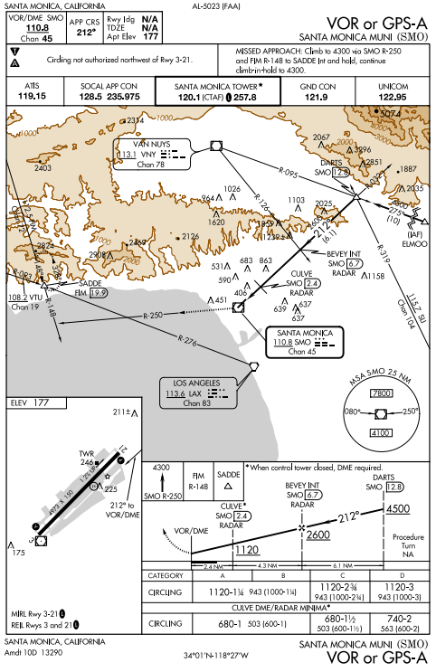
It is steep. The last segment has a slope of more than 3.5 degrees, marking it as the Instrument Approach equivalent of a black diamond ski slope. (The approach segments are all straight lines. If you have steep portions and some parts of the approach are DME arcs? That makes it a double black diamond.)
It is offset. This matters more to a jet pilot than to me. You follow the 212 radial off the Santa Monica VOR the to field. The runway is on a heading of 210 and the VOR beacon is at the far end of the runway. That means that when you drop out of the clouds you have to get the plane over onto the extended centerline of the runway. When the ceiling is low, larger (faster) planes drop out of the cloud over the I-10/I-405 interchange and you can see them wiggle in the sky trying to get lined up for a landing. I have stood by our plane watching the jet jockeys try to make it onto the ground only to see them have to spool the engines up, climb back up into the clouds and head over to Van Nuys airport. This is called "going missed" and it costs thousands of dollars in fuel and, depending on your customer, additional transportation when you finally get on the ground.
One of those times I watched a charter jet go missed, I had just landed myself and it was gratifying to have brought it down safely when the pilots getting paid to fly were unable to. (That's totally unfair, I could land on a fifth of the runway without too much trouble. The jets really need the whole length so if they can't put it down right at the beginning they need to go somewhere else or try again.) Sometimes I've watched, and you can tell from where the plane drops out of the clouds that the pilot has cheated a little and flown a few degrees right of course so that they come out lined up with the runway. (That's not difficult to do with today's moving maps and WAAS GPS units. I am not even sure it is outside of regulations. They aren't deviating very much from the described path of the approach.)
Often, you are too high. And not because you haven't planned well. You are under positive control by SoCal's Air Traffic Control and they assign each of your altitudes, decreasing as you get to the beginning of the approach. I am usually brought over the Van Nuys and Burbank airports at 5,000 feet. When I am two miles from DARTS the controller usually clears me down to 3,500 and clears me for the approach. So I have about eight nautical miles before BEVEY (over Beverly Hills, the initial navigation fix on the approach) and I am meant to descend to 2,600 feet, losing half my altitude in less than four minutes. That’s only a little more than six hundred feet per minute and it shouldn’t be a big deal, but it puts pressure on the pilot. Enough pressure that a jet pilot flying his Citation (which he did every weekend, it seemed) came in too fast, too high, and departed the runway crashing into a hangar and killing everyone on board the plane.
This sort of handling by controllers of planes into airports is known as “a slam dunk.” It is part of what contributed to the crash of Asiana Flight 214. The controllers moving planes into SFO tend to keep them high, expecting the pilots to be able to scream down from the skies and slide smoothly onto the runway. Managing the energy (from potential to kinetic) can be tricky, even with autopilots and computers doing a lot of the work. The Korean flight crew recognized at first that their problem was they were too high and fast, and worked hard to correct that. In the end they overcorrected and wound up too low and slow, with disastrous results.
But (and the NTSB agrees) pilots should be able to handle slam dunk approaches. It just requires planning. I’m lucky, because our plane is very forgiving and I’ve come over the fence carrying 138 knots of airspeed, easily twice what I needed, and I was able to bleed the speed off and put the wheels down on the thousand foot markers, just where I was meant to. (That was at Dulles International, and as the only propeller plane on the field I had a large audience.) And, as mentioned before, I can land in less than fifteen hundred feet and I have almost five thousand at Santa Monica.
The marine layer along the coast is the bane of VFR pilots, but it’s nearly meaningless to IFR pilots. It is often less than two hundred feet thick. So an overcast sky (a ceiling) at 600 feet above the runway (which is what was reported at Santa Monica as we were crossing over Van Nuys) has it’s bottom at 800 feet MSL (the airport is at 200 feet Mean Sea Level) and the tops are just over a thousand feet. As you are descending at the recommended 500 feet per minute, these clouds whip past your windscreen in thirty seconds. (Fun fact: NASA did a study and found that VFR pilots get spatial disorientation in less than thirty seconds of entering the clouds!)
But that’s another frustration of the held-high-by-ATC approach: I am often looking down at this soft blanket of clouds knowing that I could just duck through it with a little flick of the control stick. And this is the whole point of this shorter-than-usual entry because I received an instruction from ATC that I never had heard before:
SoCal: Niner seven one romeo delta, cleared to descend VFR and cleared for the VOR approach to Santa Monica.
I had to ask if there was an altitude that I was cleared to descend to.
SoCal: One romeo delta, affirmative, descend VFR and then cleared for the approach.
So as long as I could see outside, I could descend to whatever altitude I wanted. Then, once I bottomed out on the clouds, I would have to wait for the step-downs prescribed by the instrument approach. That’s 2,600 feet at BEVEY and 1,120 at CULVE (over Culver City). After CULVE I would be allowed to descend to 680 feet, just 480 above the runway. (Technically the airport is at 177 feet, but I round that to 200 feet for my thumbnail calculations.) I dropped the nose and we started skimming the tops of the clouds at 1,200 feet.
The approach was complicated a little because it was after 9pm. The tower at Santa Monica closes at 9pm and then the rules change for instrument approaches. Essentially, you need to be able to spot the airport at the CULVE intersection or before, otherwise you need to go missed and land somewhere else. SoCal can’t see you low enough to follow you all the way to touch down, and they don’t want to risk having you flying around in the Santa Monica class D airspace unable to talk to you. While there is an instrument-flight-rules flight in the Santa Monica airspace they need to keep the north runway of LAX closed to arrivals. They can’t tolerate having that cut off for hours, even just the chance of that. So just as I was just ducking into the clouds, thirty seconds from popping out the bottom, the controller was giving me her usually spiel: “One romeo delta, you will need to cancel IFR in the next two miles or go missed on the approach. Acknowledge.”

When you enter the clouds at night, your strobe lights reflect back at you. It turns everything into a bit of a horror show. So I clicked those off. I was hand flying, because I was going to make a few quick adjustments to our course as I came out the bottom of the clouds and I didn’t want to be fiddling with the autopilot to do it. The G1000’s moving map can be set to show terrain colored according to how close you are to it. If you are doing an instrument approach in a mountainous area this can be really reassuring. I have it turned on whenever I am heading into the clouds because there are enough accidents where pilots have flown into a mountain after getting turned around on the approach. (You would think that because I have flown this particular approach more times than any other approach that I wouldn’t have to worry about eliminating a risk like that… and that’s how people wind up flying into mountains, too.)
With the terrain awareness on, the moving map was turning yellow and quickly red. I knew where I was (out on the flats between Beverly Hills and Culver City) and terrain wouldn’t be my issue. The all-yellow screen was obscuring the view of the little plus marks that marked obstacles. On the approach into Santa Monica the most important obstacles are the tall building near Century City. In particular, there’s a pair of apartment buildings (the tower calls them out as “twin towers,” but they aren’t that big). Once you are past those you’d be safe to descend to 500 feet MSL without any obstacles, but until you are past them you should be aware of where they are. So I flicked off the terrain shading on the moving map. (After we landed, Nell said she didn’t like seeing it start to get all bright yellow and red while we were descending through the clouds.)
With the terrain shading off I could see the little + markers easily. We were well to the left of the apartment buildings and just about to pass them. I cheated a little to the right. Just as I was adjusting us a little on the approach, I saw the lights of the streets and buildings below. Instantly I keyed the mike and said, “One romeo delta has the field, is canceling IFR and switching to advisory frequency, thanks for your help.”
During training we had a night flight, a long cross country from Santa Monica up to Paso Robles. I flew up and Adam flew back down. On the way up I had the chart out and was checking it with my little red flashlight. I’d see a feature, like the 101 snaking up alongside San Luis Obispo, and say, “There’s the highway down there, there’s the town, there’s the next town over…” After we landed and were switching pilots Adam said, “This is totally unfair, you look down there and it all makes sense to you.” That’s true. There’s some plan-oriented part of my brain that has always lit up for the pattern-matching fun of abstraction mapping onto reality.
That helps a lot when you are falling out the bottom of the clouds and your nose is pointed down at a bunch of blinking lights, sliding cars, and dark shapes that might be a golf course. In an instant I knew I was over the Westside Pavilions Mall, and a little pull on the stick and we were pointed at the approach end of runway two-one. I announced us on the CTAF just in case there was a helicopter transitioning the airspace and put us down on the fog-damp tarmac.
An excellent use of the plane, a tight instrument approach demonstrating a good use of the instrument rating, and I learned something new. I wonder if I can request that clearance next time.
1 comment
You probably can request it, and I'm kind of surprised you got that clearance without doing so. According to the pilot/controller glossary:
VFR CONDITIONS- Weather conditions equal to or better than the minimum for flight under visual
flight rules. The term may be used as an ATC clearance/instruction only when:
a. An IFR aircraft requests a climb/descent in VFR conditions.
b. The clearance will result in noise abatement benefits where part of the IFR departure route does not conform to an FAA approved noise abatement route or altitude.
c. A pilot has requested a practice instrument approach and is not on an IFR flight plan.
Note: All pilots receiving this authorization must comply with the VFR visibility and distance from cloud criteria in 14 CFR Part 91. Use of the term does not relieve controllers of their responsibility to separate aircraft in Class B and Class C airspace or TRSAs as required by FAAO JO 7110.65. When used as an ATC clearance/instruction, the term may be abbreviated “VFR;” e.g., “MAINTAIN
VFR,” “CLIMB/DESCEND VFR,” etc.
(The actual rule for ATC is in 7110.65 7-1-2.)