I love when reality final catches up with my future. Apple and Foreflight have delivered the Electronic Flight Bag that I was waiting for ever since I bought my first NACO book of instrument approach plates. Why was I dragging around all this paper? Why was I sitting in the run up area flipping through this booklet trying to find the departure procedure for taking off from KPOC in Pomona, which of course is under B for Brackett Field?
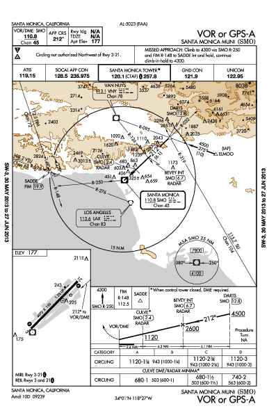
I’m going to shrink all these graphics, but clicking on them will make them nice and big. Here is the approach plate to fly into Santa Monica when you can’t see the airport because of an overcast layer of clouds. I had to do this recently when I was returning from San Diego, where I dropped off some friends. The weather looked great when I departed, was even better than forecast all the way down to Lindbergh Field, and then on the way back up the clouds closed in faster and faster over little KSMO until it was covered with an overcast layer of clouds, a ceiling of 1,600 feet.
So I called SoCal Approach Control on the radio and said I would need an instrument approach clearance into the airport. I let Otto take over while I copied the clearance. Once I was cleared to the airport, if I lost radio contact somehow, I was still allowed to fly the approach all the way to landing. I was to fly over LAX (right near the Los Angeles VOR in the map image) at 4,000 feet to the Santa Monica VOR. Then I would turn outbound to the ELMOO intersection (over land that was originally a dairy farm, get it?). At ELMOO I would turn inbound on the approach, descending on the steps detailed in the profile view. Somewhere between BEVEY (over Beverly Hills) and CULVE (over Culver City) I will fly out of the bottom of the clouds at 1,600 feet and see the airport.
If I don’t, I can only fly down to 680 feet before I have to “go missed,” which means I fly past the airport, out over the ocean and up toward the SADDE intersection (over Saddle Peak) and hang out until the air traffic people work out another plan with me. (That’s never happened to me, any time I have started an instrument approach to an airport I have landed there.)
Not every airport has an instrument approach procedure, but every medium-sized airport does. And I am always within range of such an airport. They are, as you can see in the example, very precise. If you fly exactly where they tell you to fly, following the navigational radio beams on the settings they describe, you will have a nice margin of error around your path (including clearance below you for terrain and obstacles). You will arrive safely at the airport.
It’s against regulations to fly the approach without a written description. (That’s why I am able to draw the approach into Santa Monica on a blank sheet of paper from memory. I always “have it with me.”) The approach plates expire every six weeks or so. The government printing office rolls them out in booklet form, with each book covering a state or several states. California has so many airports we need two books, one for Southern California and one for Northern. I subscribe to the two California books and the Nevada/Arizona/New Mexico book through a website and they send them every six weeks. That’s twenty-two bucks every month and a half.
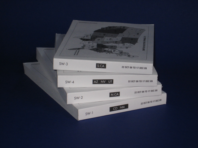
Here is that stack of updates before I take the from the house to the plane. You have to also have "the green book," the facilities directory, with you. It counts as “all available information” about your flight into unfamiliar airports, something you are required to have by regulation. (What is the elevation of the airport? How long is the runway? What are the frequencies for communications related to the airport? Is there fuel available there? All that’s in the green book.) So each book is about three quarters of an inch and probably half a pound.
Flying across the country, I need to stock up on all the necessary approach books for the entire trip. Then I have to err on the side of including a book without knowing for sure what our route will be. Getting NE-1 and NE-2 is obviously, since that covers a lot of the Eastern seaboard and our destinations on that end. But do I need SC-1 for Oklahoma and Arkansas? We landed in Tulsa on the way back from Spring Break one year, steering a little south for weather. That means we skipped right out of NC-3 territory, even though that book was sitting quietly in the back, taking up space and a pound of our available payload.
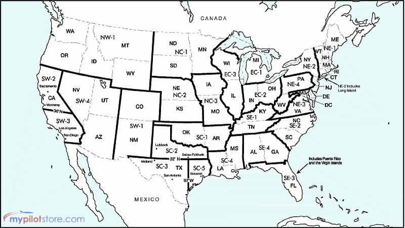
Looking at the map you can see that to get across requires something like a dozen or fifteen books. With the associated green books it winds up being a hundred twenty dollars in charts. Between our spring and summer flights they all expire and need to be replaced. It’s a significant chunk of baggage space and needs to be accessible (Rudy will go rooting through the bag for me, passing up the NE-2 book when I ask for it.)
The part of the whole endeavor that really bothers me is that six weeks can easily go by and I won’t use the Arizona book. And I’ve almost never cracked open any of the green books. The last trip across for the summer (and return trip) we used three approach plates (Lebanon, NH, Antrim County, MI and a departure plate out of St. Louis, MO). We could have gotten away with just three books, but there is no way to know that. Hundreds of pages of newsprint dumped in the trash after each trip (and smaller amounts every six weeks for the three books I always need).
Why can’t technology save me from this mess?
I bought a Kindle when they first came out. I looked into getting the approach plates as PDF files (Portable Document Format, a sort of universal file for display and printing). But there is a little bit of subtlety in the display of the plates and I didn’t really like the way they looked on the Kindles screen. My Kindle 2 was a slicker item than my Kindle 1 (which was handed down to my eldest son for reading in the plane), but the screen was the same size. And it wasn’t really big enough for a full approach plate. The e-ink display the Kindle uses doesn’t do smooth scrolling or even smooth updates, so flipping back and forth between the plan and profile views of the approach is not natural. Navigating through a PDF file was no fun and not something I would want to do in the cockpit while bouncing around in the clouds.
I have an iPhone and I bought ForeFlight for it. It’s a great little application, especially for watching the radar map of precipitation sweep over the airport while you are having lunch nearby. Then you know to slow down, have a dessert, and that you’ll be on your way in another hour or so. And they let you download approach plates, but the iPhone screen is really tiny, so that’s not useful for anything other than a dreadful emergency.
The G1000 has a couple nice big 10” diagonal screens. For $800 a year Jeppesen will deliver the instrument procedures for the country to a little card that I can update every six weeks and the plates will show up on the screen right there in front of my co-pilot. I’ve tried it (there was a trial version for free). I don’t like losing the moving map on that screen. And I don’t want to look over for the approach plate information. It really didn’t feel like a very good solution. I bet if I had a Mustang jet with three screens (moving map in the middle), and a co-pilot who was in charge of reading the information off the approach plate for me it would work really well. I’ll keep that in mind for when I get the Mustang.
A friend has the Kindle DX. A much larger screen and it looked like it would be big enough for a full approach plate. I looked into Nacomatic again and another solution that packaged the PDFs up for you. It still didn’t feel comfortable and there was a rumor Apple was coming out with a tablet. A game changer.
Exactly.
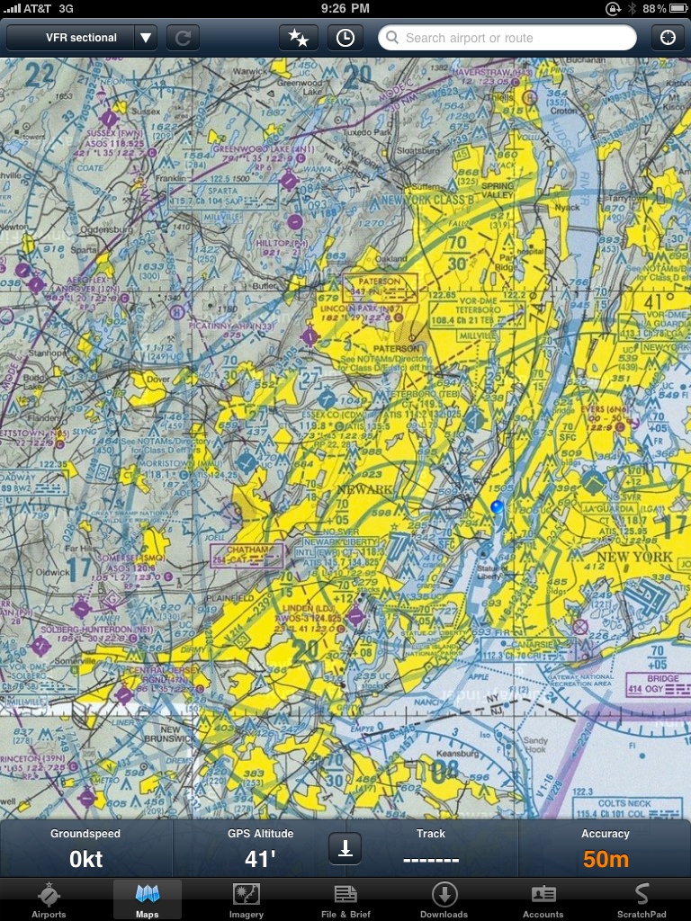
This is a screenshot of ForeFlight HD. It runs fine on my iPad (just the lowest-end WiFi model). Right now it automatically updates itself with all of the VFR and IFR charts for my region of the country and all of the instrument procedures for California, Arizona, New Mexico and Nevada. In July when I fly across I will set it to download the entire country of charts and instrument procedures.
It has diagrams of every airport across the country and the FBOs at each of those airports, complete with phone numbers. That means when we land at our lunch stop and plan where to land for dinner, Nell can call ahead and talk to them about possible hotels. It downloads weather information. You can see weather maps, the VFR chart for an area, or the Victor airways of the IFR chart. Most importantly, it downloads all of the instrument procedures for each airport. So as I am flying into Santa Monica from Las Vegas if they say, “Expect the KIMMO-2 arrival I can bring that up on the iPad in a couple taps of my finger.
(Incidentally, there’s a departure procedure out of Van Nuys airport. It’s the Glendale-9 departure and I am pretty sure I have gotten every time I’ve flown out of KVNY on an instrument flight. It’s simple: climb on the runway heading until 2.2 nautical miles from the VNY VOR, then turn to a heading of 110 degrees to get vectors to the VNY 095 radial to the ADAMM intersection. I could probably fly it from memory (especially in VFR conditions, which is what I am usually doing), but I am meant to have a written description of it at hand when I start the flight. For whatever reason it is hard to find in the NACO book. Other procedures I find easily, but that one hides from me. On the iPad it was tap-tap-tap and there it was. Amazing.)
I had to get this big, padded case for the iPad. The huge glass surface is an invitation for scratches and when I am flying the plane I don’t worry that much about things getting banged around in the cockpit; I’m very focused on making sure the plane stays where it needs to and is pointed the right way. So the incase case has a lot of padding, stiffness, and covers up the iPad nicely. It adds a little weight to Apple’s slim little package, but that’s all fine in the name of making it less vulnerable.
Currently I can only update if I have WiFi connectivity, but friends have the 3g model and I’m waiting to see what a couple months with this is like. I’ve already flown into Chino using the iPad and I used it on the return from San Diego that I mentioned before. It’s been perfect. I can’t wait for the trip across this summer.
(The iPad was $500. The Foreflight subscription works for both the iPhone and the iPad and is $70 a year. The year we flew across on both spring and summer breaks we spent $120 each break for charts along with the $180 for the six-week updates throughout the year. $420 for charts in the year. And I think I can ditch the little brown Airport Guide books, which are another $30 each (three cover the country). But the truth is I love not carrying the things I don’t use, and I like not throwing away paper I have never seen.)